
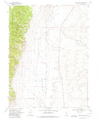
1969 Map of Vigus Butte NW
USGS Topo · Published 1971About this map
White House Ranch sits along the braided course of the Reese River in this arid Nevada landscape mapped in the late 1960s. The terrain transitions from the steep, shaded contours of the Ravenswood range in the west to the alluvial fan where Garden Spring and Italian Cr descend toward the valley floor. The map documents early industrial and transportation attempts in Lander County, marked by an Old Railroad Grade that cuts across the northern flats and several extraction sites like the Ladida Pit and a remote Prospect. Long-established water sources and drainage patterns, including Silver Creek and various wells, define the life and economy of this high-desert region, while several segments of Jeep Trail provide the only access into the more forbidding upland areas.
Find a feature on this map
14 named features on this map. Tap any name to fly to it.
Don’t see what you’re looking for? This feature index may not catch every label — zoom into the map to look around manually.
Map Details
Editions of this 1969 Vigus Butte NW Map
2 editions found
Other maps of this area

1955 · Millett
USGS Topo · 1:250,000

1959 · Millett
USGS Topo · 1:250,000

1969 · Manhattan Mtn
USGS Topo · 1:24,000

1969 · Gilbert Creek SE
USGS Topo · 1:24,000

1969 · Joe Eason Mtn
USGS Topo · 1:24,000

1969 · Yankee Blade
USGS Topo · 1:24,000

1969 · Vigus Butte NE
USGS Topo · 1:24,000

1969 · Vigus Butte
USGS Topo · 1:24,000

1969 · Mount Airy NE
USGS Topo · 1:24,000

1969 · Mount Airy Mesa
USGS Topo · 1:24,000