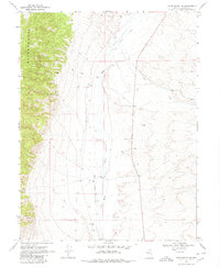
1969 Map of Vigus Butte NW
USGS Topo · Published 1980About this map
White House Ranch sits at the heart of this high-desert basin, situated along the course of the Reese River. The landscape is defined by the sharp transition from the elevated peaks of Ravenwood in the west to the alluvial plains bisected by an Old Railroad Grade. This transport corridor, running roughly parallel to the river, marks a former era of connectivity through Lander County. Human activity is further evidenced by a scattered Prospect at the base of the mountains and aggregate extraction sites such as the Ladida Pit and a Borrow Pit. Water remains the critical resource for the area, with Silver Creek flowing from the east and Garden Spring providing a reliable source within the mountain folds. Several bench marks, including BM 5528 near the ranch, provide precise elevation data for this corner of the Great Basin.
Find a feature on this map
22 named features on this map. Tap any name to fly to it.
Don’t see what you’re looking for? This feature index may not catch every label — zoom into the map to look around manually.
Map Details
Editions of this 1969 Vigus Butte NW Map
2 editions found
Other maps of this area

1955 · Millett
USGS Topo · 1:250,000

1959 · Millett
USGS Topo · 1:250,000

1969 · Manhattan Mtn
USGS Topo · 1:24,000

1969 · Gilbert Creek SE
USGS Topo · 1:24,000

1969 · Joe Eason Mtn
USGS Topo · 1:24,000

1969 · Yankee Blade
USGS Topo · 1:24,000

1969 · Vigus Butte NE
USGS Topo · 1:24,000

1969 · Vigus Butte
USGS Topo · 1:24,000

1969 · Vigus Butte NW
USGS Topo · 1:24,000

1969 · Mount Airy NE
USGS Topo · 1:24,000