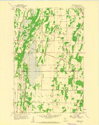
1959 Map of Viking
USGS Topo · Published 1977About this map
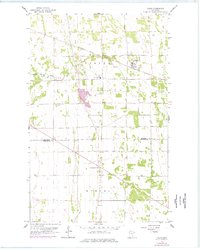
The town of Viking sits as a primary rail hub along the Minneapolis St Paul and Sault Ste Marie line in this Northwestern Minnesota landscape. The map details a transition between township boundaries and natural drainage, where the South Branch Snake River meanders through the western section of the quadrangle. Local civic life is anchored by the Town Hall and the rural junction at Carpenters Corner, reflecting a mid-century agricultural and transportation network. Infrastructure supporting the area includes a prominent Radio Tower and Pumping Station, while several extractive sites like a Gravel Pit and a large Pit near the river signify the local importance of aggregate materials for road building and maintenance during this era.
Find a feature on this map
12 named features on this map. Tap any name to fly to it.
Don’t see what you’re looking for? This feature index may not catch every label — zoom into the map to look around manually.
Map Details
Editions of this 1959 Viking Map
2 editions found
Other maps of this area

1918 · Angus
USGS Topo · 1:62,500
1918 · Viking
USGS Topo · 1:62,500

1952 · Thief River Falls
USGS Topo · 1:250,000

1956 · Thief River Falls
USGS Topo · 1:250,000
1956 · Florian
USGS Topo · 1:62,500

1957 · Thief River Falls
USGS Topo · 1:250,000
1957 · Newfolden
USGS Topo · 1:62,500

1959 · Viking
USGS Topo · 1:24,000
1959 · Rosewood
USGS Topo · 1:24,000
1959 · Viking SW
USGS Topo · 1:24,000