
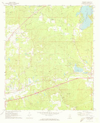
1971 Map of Vimville
USGS Topo · Published 1973About this map
Vimville and the southern reaches of Lauderdale County are defined here by a network of rural schools and family-centered community sites in the early 1970s. The landscape is carved by Buckatunna Creek and the Long Creek Reservoir, with small settlements like Increase linked by winding roads through wooded terrain. Local education is centered around the Jeff Davis Academy and Southeast Lauderdale High Sch, while several combined church and cemetery sites, including Shiloh Ch & Cem and Causeyville Ch & Cem, serve as primary landmarks for genealogists and local historians. This era shows a community in balance between its agrarian roots and modern developments like the Pumping Station and a nearby Golf Course. Multiple sand and gravel operations, such as the Gravel Pit and various Sandpits, indicate the local mineral extraction that helped build the region's infrastructure.
Find a feature on this map
38 named features on this map. Tap any name to fly to it.
Don’t see what you’re looking for? This feature index may not catch every label — zoom into the map to look around manually.
Map Details
Editions of this 1971 Vimville Map
This is the sole edition of this map. No revisions or reprints were ever made.
Other maps of this area

1921 · Meridian
USGS Topo · 1:48,000

1923 · Meridian
USGS Topo · 1:62,500

1953 · Meridian
USGS Topo · 1:250,000

1957 · Meridian
USGS Topo · 1:250,000

1957 · Quitman
USGS Topo · 1:62,500

1965 · Meridian
USGS Topo · 1:250,000

1971 · Meridian South
USGS Topo · 1:24,000

1971 · Meridian North
USGS Topo · 1:24,000
1971 · Toomsuba
USGS Topo · 1:24,000

1974 · Yantley
USGS Topo · 1:24,000