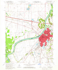
1965 Map of Vincennes
USGS Topo · Published 1966About this map
Vincennes sits at a historic river crossing where the Wabash River forms the border between Illinois and Indiana. The mid-1960s city landscape is dominated by its educational and civic institutions, featuring Vincennes University, several parochial schools like St Johns Sch, and the George Rogers Clark State Memorial on the riverbank. This survey highlights the complex drainage systems and levees required to manage the floodplain, such as the Denison Levee and Allison Ditch, which crisscross the agricultural flats of Allison to the west. On the Indiana side, the town’s growth is shaped by major transportation arteries, including the Baltimore and Ohio and Chicago and Eastern Illinois railroads. Local landmarks like the Courthouse, the Indian Mound near Mirror Lake, and numerous cemeteries including Memorial Park Cemetery provide deep points of reference for genealogists and local historians studying the city's mid-century footprint.
Find a feature on this map
66 named features on this map. Tap any name to fly to it.
Don’t see what you’re looking for? This feature index may not catch every label — zoom into the map to look around manually.
Map Details
Editions of this 1965 Vincennes Map
4 editions found
Other maps of this area

1915 · Vincennes
USGS Topo · 1:62,500

1917 · Birds
USGS Topo · 1:62,500

1942 · Fritchton
USGS Topo · 1:24,000

1942 · Birds
USGS Topo · 1:62,500

1943 · Oaktown
USGS Topo · 1:24,000

1944 · Fritchton
USGS Topo · 1:24,000

1944 · Iona
USGS Topo · 1:24,000

1944 · Vincennes
USGS Topo · 1:62,500

1956 · Vincennes
USGS Topo · 1:250,000

1957 · Vincennes
USGS Topo · 1:250,000