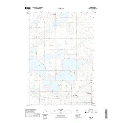
2019 Map of Vining
USGS Topo · Published 2019About this map
Vining sits at the southern edge of this lake-heavy landscape in Otter Tail County, positioned between the shorelines of Stuart Lake and East Battle Lake. The terrain is defined by a dense concentration of glacial basins, ranging from the expansive West Battle Lake to smaller, secluded waters like Tamarack Lake, Gourd Lake, and Bullhead Lake. Local history and family lineages are anchored at the Girard Cem north of the village, while a network of rural routes including Chippewa Trl, Blackjack Dr, and Brandborg Creek Rd connect the various peninsulas and lakefronts. The map illustrates a complex drainage pattern, with Brandborg Cr and numerous unnamed wetlands surrounding features like West Mason Lake and East Mason Lake, reflecting a region deeply shaped by its aquatic geography and long-standing recreational and agricultural significance.
Find a feature on this map
67 named features on this map. Tap any name to fly to it.
Don’t see what you’re looking for? This feature index may not catch every label — zoom into the map to look around manually.
Map Details
Editions of this 2019 Vining Map
This is the sole edition of this map. No revisions or reprints were ever made.
Other maps of this area

1912 · Battle Lake
USGS Topo · 1:62,500

1914 · Battle Lake
USGS Topo · 1:62,500

1953 · Brainerd
USGS Topo · 1:250,000

1957 · Brainerd
USGS Topo · 1:250,000

1958 · Brainerd
USGS Topo · 1:250,000

1965 · Brainerd
USGS Topo · 1:250,000

1969 · Henning
USGS Topo · 1:24,000

1969 · Eagle Lake
USGS Topo · 1:24,000
1969 · Parkers Prairie NW
USGS Topo · 1:24,000

1969 · Heinola
USGS Topo · 1:24,000