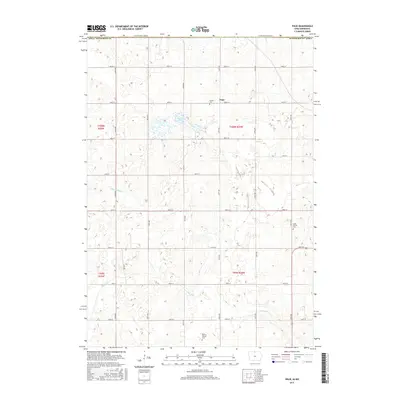
2015 Map of Vinje
USGS Topo · Published 2015About this map
Vinje serves as the central settlement in this agricultural section of Winnebago County, Iowa, as it appeared in the mid-2010s. The landscape is defined by the rectilinear grid of local roads, such as 150th Ave and 490th St, which trace the township and range boundaries established by the Public Land Survey System. Genealogical interest is concentrated at three local burial grounds: Bethel Cem near the town center, North Prairie Cem in the east, and Holmes Chapel Cem to the south.
Find a feature on this map
28 named features on this map. Tap any name to fly to it.
Don’t see what you’re looking for? This feature index may not catch every label — zoom into the map to look around manually.
Map Details
Editions of this 2015 Vinje Map
This is the sole edition of this map. No revisions or reprints were ever made.
Other maps of this area

1954 · Mason City
USGS Topo · 1:250,000

1955 · Bricelyn
USGS Topo · 1:62,500

1955 · Wells
USGS Topo · 1:62,500

1957 · Mason City
USGS Topo · 1:250,000

1958 · Mason City
USGS Topo · 1:250,000

1972 · Forest City
USGS Topo · 1:24,000

1972 · Buffalo Center NE
USGS Topo · 1:24,000

1972 · Pilot Knob
USGS Topo · 1:24,000

1972 · Vinje
USGS Topo · 1:24,000
1972 · Thompson
USGS Topo · 1:24,000