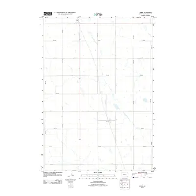
2012 Map of Virgil
USGS Topo · Published 2012About this map
Cain Cr meanders southeast across this agricultural section of Beadle County, defining the drainage patterns of the prairie landscape. The area is organized by a precise grid of rural section-line roads, including 387th Ave and 209th St, which facilitate transport through the vast farmlands. A localized concentration of development appears near the intersection of Railroad Ave and E Main St, indicating the historical significance of the rail corridor in shaping local infrastructure. Small pockets of wetland and intermittent water bodies are scattered throughout the quadrangle, illustrating the natural topography that underlies the intensive agricultural use of the South Dakota plains. The mapping reflects the enduring structure of township and range divisions, where individual homesteads and farmsteads are accessed via thoroughfares like 214th St and 392nd Ave.
Find a feature on this map
19 named features on this map. Tap any name to fly to it.
Don’t see what you’re looking for? This feature index may not catch every label — zoom into the map to look around manually.
Map Details
Editions of this 2012 Virgil Map
This is the sole edition of this map. No revisions or reprints were ever made.
Other maps of this area

1898 · Huron
USGS Topo · 1:125,000

1950 · Wessington NE
USGS Topo · 1:24,000

1951 · Wessington SE
USGS Topo · 1:24,000

1953 · Huron
USGS Topo · 1:250,000

1954 · Huron
USGS Topo · 1:250,000
1973 · Wolsey
USGS Topo · 1:24,000

1973 · Alpena
USGS Topo · 1:24,000

1973 · Wessington Springs NE
USGS Topo · 1:24,000
1973 · Broadland
USGS Topo · 1:24,000
1973 · Virgil
USGS Topo · 1:24,000