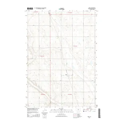
2015 Map of Virgil
USGS Topo · Published 2015About this map
The small community of Virgil serves as the central hub of this prairie landscape in Beadle County, located at the junction of Cr-26 and several local routes. The town is situated along Railroad Ave, reflecting the historic importance of rail transport for agricultural distribution in the region. The surrounding terrain is defined by the winding course of Cain Creek, which meanders across the township lines of t110n r63w and t111n r63w. The map details a strictly organized grid of rural roads, including 390th Ave and 213th St, which partition the land into the traditional sections of the Public Land Survey System. This layout illustrates the enduring agricultural character of the South Dakota plains, where small settlements like Virgil provided essential services to a network of isolated farmsteads.
Find a feature on this map
27 named features on this map. Tap any name to fly to it.
Don’t see what you’re looking for? This feature index may not catch every label — zoom into the map to look around manually.
Map Details
Editions of this 2015 Virgil Map
This is the sole edition of this map. No revisions or reprints were ever made.
Other maps of this area

1898 · Huron
USGS Topo · 1:125,000

1950 · Wessington NE
USGS Topo · 1:24,000

1951 · Wessington SE
USGS Topo · 1:24,000

1953 · Huron
USGS Topo · 1:250,000

1954 · Huron
USGS Topo · 1:250,000
1973 · Wolsey
USGS Topo · 1:24,000

1973 · Alpena
USGS Topo · 1:24,000

1973 · Wessington Springs NE
USGS Topo · 1:24,000
1973 · Broadland
USGS Topo · 1:24,000
1973 · Virgil
USGS Topo · 1:24,000