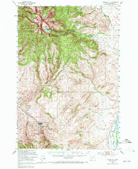
1950 Map of Virginia City
USGS Topo · Published 1972About this map
Virginia City sits at the base of the high peaks within the Beaverhead Mountains, serving as a focal point for this 1950 survey. The landscape is heavily marked by the region's mining heritage, with a dense concentration of workings such as the Alameda Mine, Black Rock Mine, and El Ebano Mine clustered in the gulches near the settlement. These claims follow the rugged topography south of Ramshorn Mountain and South Baldy Mountain, where the timber of the Beaverhead National Forest meets the rocky ridges.
Find a feature on this map
38 named features on this map. Tap any name to fly to it.
Don’t see what you’re looking for? This feature index may not catch every label — zoom into the map to look around manually.
Map Details
Editions of this 1950 Virginia City Map
5 editions found

Other maps of this area

1888 · Three Forks
USGS Topo · 1:250,000

1893 · Dillon
USGS Topo · 1:250,000

1894 · Three Forks
USGS Topo · 1:250,000

1895 · Three Forks
USGS Topo · 1:250,000

1947 · Bozeman
USGS Topo · 1:250,000

1948 · Bozeman
USGS Topo · 1:250,000

1949 · Varney
USGS Topo · 1:62,500

1949 · Ennis
USGS Topo · 1:62,500

1949 · Norris
USGS Topo · 1:62,500

1950 · Cameron
USGS Topo · 1:62,500