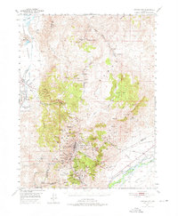
1950 Map of Virginia City
USGS Topo · Published 1976About this map
Virginia City and the surrounding Comstock Lode district appear here during a period of transition in the mid-twentieth century. The map documentation reveals the dense industrial footprint of silver and gold mining, showing a landscape riddled with historic works like the Yellow Jacket Mine, Belcher Mine, and the massive Sutro Tunnel which drains the hills toward the Carson River. The terrain is dominated by the Virginia Range and peaks such as Mt Davidson, overlooking the canyon settlements of Gold Hill and Silver City. While some areas show signs of fading, such as Lousetown and the dismantled railroad, others like Steamboat Springs and the irrigation network of Chandler Ditch in the Truckee Meadows highlight the region's evolving agricultural and geothermal activity. The survey also captures local community landmarks including Browns Sch and the remote settlement of Jumbo.
Find a feature on this map
82 named features on this map. Tap any name to fly to it.
Don’t see what you’re looking for? This feature index may not catch every label — zoom into the map to look around manually.
Map Details
Editions of this 1950 Virginia City Map
3 editions found
Other maps of this area

1890 · Wadsworth
USGS Topo · 1:125,000

1891 · Carson
USGS Topo · 1:125,000

1891 · Wabuska
USGS Topo · 1:125,000

1891 · Reno
USGS Topo · 1:125,000

1892 · Wadsworth
USGS Topo · 1:125,000

1893 · Carson
USGS Topo · 1:125,000

1893 · Reno
USGS Topo · 1:125,000

1894 · Wadsworth
USGS Topo · 1:125,000

1894 · Wabuska
USGS Topo · 1:125,000

1950 · Virginia City
USGS Topo · 1:62,500