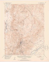
1952 Map of Virginia City
USGS Topo · Published 1952About this map
Virginia City anchors this 1952 study of the Comstock Lode's heart, capturing the high desert landscape during a period of transition for its mining infrastructure. The map meticulously documents the industrial geography of the Virginia Range, from the subterranean path of the Sutro Tunnel to the specialized shafts that defined the district, including the Utah Shaft, Union Shaft, and Mint Shaft. Beyond the primary settlements of Gold Hill and Silver City, the survey identifies several former habitations now marked as sites, such as Lousetown and Washington.
Find a feature on this map
48 named features on this map. Tap any name to fly to it.
Don’t see what you’re looking for? This feature index may not catch every label — zoom into the map to look around manually.
Map Details
Editions of this 1952 Virginia City Map
2 editions found

Other maps of this area

1890 · Wadsworth
USGS Topo · 1:125,000

1891 · Carson
USGS Topo · 1:125,000

1891 · Wabuska
USGS Topo · 1:125,000

1891 · Reno
USGS Topo · 1:125,000

1892 · Wadsworth
USGS Topo · 1:125,000

1893 · Carson
USGS Topo · 1:125,000

1893 · Reno
USGS Topo · 1:125,000

1894 · Wadsworth
USGS Topo · 1:125,000

1894 · Wabuska
USGS Topo · 1:125,000

1950 · Virginia City
USGS Topo · 1:62,500