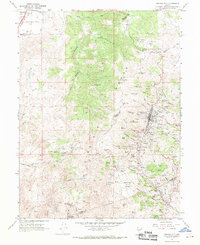
1967 Map of Virginia City
USGS Topo · Published 1971About this map
Virginia City and the surrounding Comstock Lode district appear here during a period of mid-century stabilization, showing the dense concentration of mining infrastructure that defined this region's industrial legacy. The landscape is a complex network of shafts and ravines, from Ophir Hill down through Gold Hill and Silver City. Evidence of the massive 19th-century engineering required to drain these mines is visible in the Sutro Tunnel and the Aqueduct system winding through the hills.
Find a feature on this map
120 named features on this map. Tap any name to fly to it.
Don’t see what you’re looking for? This feature index may not catch every label — zoom into the map to look around manually.
Map Details
Editions of this 1967 Virginia City Map
3 editions found
Other maps of this area

1891 · Carson
USGS Topo · 1:125,000

1893 · Carson
USGS Topo · 1:125,000

1950 · Virginia City
USGS Topo · 1:62,500

1950 · Mt. Rose
USGS Topo · 1:62,500

1952 · Mt. Rose
USGS Topo · 1:62,500

1952 · Virginia City
USGS Topo · 1:62,500

1956 · Dayton
USGS Topo · 1:62,500

1956 · Carson City
USGS Topo · 1:62,500

1957 · Reno
USGS Topo · 1:250,000

1959 · Reno
USGS Topo · 1:250,000