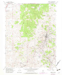
1967 Map of Virginia City
USGS Topo · Published 1983About this map
The Comstock Lode's intensive mining heritage is etched into every contour of this Nevada landscape, where Virginia City and Gold Hill stand as major centers of nineteenth-century industrial wealth. The concentration of mining infrastructure is staggering, from the Savage Mine and Chollar Mine near the town center to the deep vertical workings of the Utah Shaft and Sierra Nevada Mine to the north. These sites reveal a landscape entirely reconfigured by the hunt for silver and gold, connected by the winding Geiger Grade and the Toll Road.
Find a feature on this map
102 named features on this map. Tap any name to fly to it.
Don’t see what you’re looking for? This feature index may not catch every label — zoom into the map to look around manually.
Map Details
Editions of this 1967 Virginia City Map
3 editions found
Other maps of this area

1891 · Carson
USGS Topo · 1:125,000

1893 · Carson
USGS Topo · 1:125,000

1950 · Virginia City
USGS Topo · 1:62,500

1950 · Mt. Rose
USGS Topo · 1:62,500

1952 · Mt. Rose
USGS Topo · 1:62,500

1952 · Virginia City
USGS Topo · 1:62,500

1956 · Dayton
USGS Topo · 1:62,500

1956 · Carson City
USGS Topo · 1:62,500

1957 · Reno
USGS Topo · 1:250,000

1959 · Reno
USGS Topo · 1:250,000