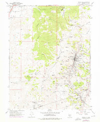
1967 Map of Virginia City
USGS Topo · Published 1976About this map
The Virginia Range anchors this detailed topographical study, which captures the legendary Comstock Lode mining district as it appeared in the late 1960s. The dense industrial footprint of Virginia City is documented alongside Gold Hill and Silver City, revealing the intense concentration of shafts and tunnels that defined the Nevada silver boom. Notable sites include the Ophir Shaft, C & C Shaft, and the entrance to the massive Sutro Tunnel, which served the local deep-mining operations.
Find a feature on this map
121 named features on this map. Tap any name to fly to it.
Don’t see what you’re looking for? This feature index may not catch every label — zoom into the map to look around manually.
Map Details
Editions of this 1967 Virginia City Map
3 editions found
Other maps of this area

1891 · Carson
USGS Topo · 1:125,000

1893 · Carson
USGS Topo · 1:125,000

1950 · Virginia City
USGS Topo · 1:62,500

1950 · Mt. Rose
USGS Topo · 1:62,500

1952 · Mt. Rose
USGS Topo · 1:62,500

1952 · Virginia City
USGS Topo · 1:62,500

1956 · Dayton
USGS Topo · 1:62,500

1956 · Carson City
USGS Topo · 1:62,500

1957 · Reno
USGS Topo · 1:250,000

1959 · Reno
USGS Topo · 1:250,000