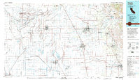
1993 Map of Visalia
USGS Topo · Published 1993About this map
The Tulare Lake Bed and its complex system of canals and sloughs dominate the western half of this Central Valley landscape, reflecting a region transformed by large-scale water management. Major waterways like the Kings River, St Johns River, and the Tule River snake across the flatlands, diverted into an intricate network including the Liberty Canal and Island Canal. The southern extent of the map features the Pixley Nat Wildlife Ref, preserved amidst the heavy agricultural footprint.
Find a feature on this map
118 named features on this map. Tap any name to fly to it.
Don’t see what you’re looking for? This feature index may not catch every label — zoom into the map to look around manually.
Map Details
Editions of this 1993 Visalia Map
2 editions found
Other maps of this area

1903 · Tehipite
USGS Topo · 1:125,000

1904 · Kaweah
USGS Topo · 1:125,000

1905 · Tehipite
USGS Topo · 1:125,000

1909 · Kaweah
USGS Topo · 1:125,000

1912 · Coalinga
USGS Topo · 1:125,000

1914 · Lost Hills
USGS Topo · 1:125,000

1914 · Cholame
USGS Topo · 1:125,000

1915 · Cholame
USGS Topo · 1:125,000

1917 · Cholame
USGS Topo · 1:125,000

1921 · Stokes Mountain
USGS Topo · 1:24,000