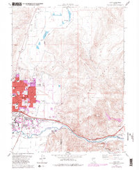
1975 Map of Vista
USGS Topo · Published 1983About this map
The eastern edges of Sparks and the canyon-cut slopes of the Pah Rah Range define this mid-1970s landscape, where industrial expansion meets the high desert. The Truckee River corridor serves as the primary artery for both transportation and utility, carrying the Southern Pacific railroad and a network of ditches and aqueducts alongside the settlement of Vista. This map captures a significant period of growth in Spanish Springs Valley, documenting educational and agricultural facilities such as Reed High Sch and the University of Nevada Farm. Beyond the urban boundary, the terrain rises toward Canoe Hill and Spanish Springs Canyon, revealing an economy of resource extraction through numerous gravel and borrow pits. High-altitude features like the Airway Beacon and Radio Towers (KOH) overlook the valley, while the residential pockets of Glendale and several trailer parks demonstrate the suburbanization occurring just before the 1980s revisions.
Find a feature on this map
48 named features on this map. Tap any name to fly to it.
Don’t see what you’re looking for? This feature index may not catch every label — zoom into the map to look around manually.
Map Details
Editions of this 1975 Vista Map
4 editions found
Other maps of this area

1891 · Carson
USGS Topo · 1:125,000

1891 · Reno
USGS Topo · 1:125,000

1893 · Carson
USGS Topo · 1:125,000

1893 · Reno
USGS Topo · 1:125,000

1950 · Virginia City
USGS Topo · 1:62,500

1950 · Mt. Rose
USGS Topo · 1:62,500

1950 · Reno
USGS Topo · 1:62,500

1951 · Reno
USGS Topo · 1:62,500

1952 · Mt. Rose
USGS Topo · 1:62,500

1952 · Virginia City
USGS Topo · 1:62,500