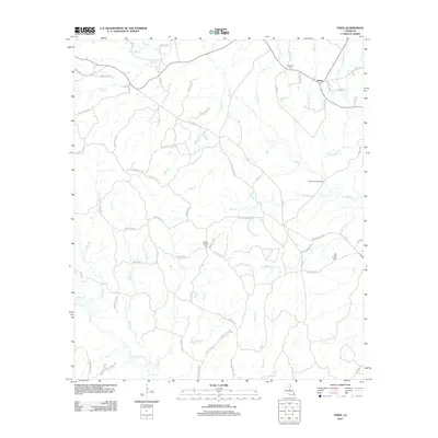
2012 Map of Vixen
USGS Topo · Published 2012About this map
The settlement of Vixen centers this northern Louisiana landscape, where a dense network of parish roads and winding creek systems defines the rural geography. The terrain is intricately carved by waterways such as Castor Cr and Humble Cr, with the notable Seven Runs Crossing appearing along Brushy Cr. For those tracing local heritage, several historic burial grounds are documented, including Palestine Cem and the Old New Church Cem near the eastern boundary. The map reflects a modern infrastructure built upon long-standing land divisions, visible in the numerous named routes like Floyd Johnston Rd and Shorty Hatten Rd that connect isolated homesteads to larger thoroughfares like Countrywood Dr. This 2012 survey provides a clear view of the drainage patterns of Beaucoup Cr and Cypress Cr in an era of established forest management and rural residential growth.
Find a feature on this map
73 named features on this map. Tap any name to fly to it.
Don’t see what you’re looking for? This feature index may not catch every label — zoom into the map to look around manually.
Map Details
Editions of this 2012 Vixen Map
This is the sole edition of this map. No revisions or reprints were ever made.
Other maps of this area

1940 · Monroe
USGS Topo · 1:62,500

1940 · Columbia
USGS Topo · 1:62,500

1953 · Chatham
USGS Topo · 1:62,500

1954 · Sikes
USGS Topo · 1:62,500

1955 · Shreveport
USGS Topo · 1:250,000

1956 · Shreveport
USGS Topo · 1:250,000

1957 · Columbia
USGS Topo · 1:62,500

1957 · Monroe South
USGS Topo · 1:62,500

1982 · Chatham
USGS Topo · 1:24,000

1982 · Chatham SE
USGS Topo · 1:24,000