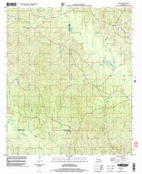
1998 Map of Vixen
USGS Topo · Published 2003About this map
Castor Creek and its many tributaries, including Bull Creek and Moody Creek, dominate this rural Louisiana landscape where the borders of Jackson, Caldwell, and Winn Parishes meet. The settlement of Vixen sits in the northeast corner of the sheet, serving as a focal point for a region characterized by dense creek networks and timbered terrain. This 1998 survey captures the area just before the turn of the millennium, showing a landscape defined by natural watercourses rather than heavy urban development. Evidence of local travel and historical routes can be found at Seven Runs Crossing and the various unnamed cemeteries (Cem) scattered across the parish lines. The intricate drainage patterns of Beaucoup Creek and Lick Creek in the south reflect the low-lying, riparian character of North Central Louisiana's piney woods and bottomlands.
Find a feature on this map
26 named features on this map. Tap any name to fly to it.
Don’t see what you’re looking for? This feature index may not catch every label — zoom into the map to look around manually.
Map Details
Editions of this 1998 Vixen Map
This is the sole edition of this map. No revisions or reprints were ever made.
Other maps of this area

1940 · Monroe
USGS Topo · 1:62,500

1940 · Columbia
USGS Topo · 1:62,500

1953 · Chatham
USGS Topo · 1:62,500

1954 · Sikes
USGS Topo · 1:62,500

1955 · Shreveport
USGS Topo · 1:250,000

1956 · Shreveport
USGS Topo · 1:250,000

1957 · Columbia
USGS Topo · 1:62,500

1957 · Monroe South
USGS Topo · 1:62,500

1982 · Chatham
USGS Topo · 1:24,000

1982 · Chatham SE
USGS Topo · 1:24,000