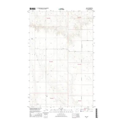
2017 Map of Volt
USGS Topo · Published 2017About this map
Volt and Tule Valley anchor this portion of Roosevelt County, Montana, where the high plains are defined by an organized grid of section lines and gravel roads. The landscape is primarily shaped by the drainage of Tule Cr and its northern tributary, N Fork Tule Cr, which cut through the undulating terrain of the Wolf Point District. Unlike many rural areas with winding paths, this region uses a strict Cartesian road network, featuring named routes such as Lustre Rd, Powder River Rd, and the curiously named Wall St. The settlement at Volt sits near the intersection of several local routes, illustrating a typical early 21st-century Montana agricultural landscape where small clusters of development were essential nodes for the surrounding ranching and farming operations across various townships.
Find a feature on this map
21 named features on this map. Tap any name to fly to it.
Don’t see what you’re looking for? This feature index may not catch every label — zoom into the map to look around manually.
Map Details
Editions of this 2017 Volt Map
This is the sole edition of this map. No revisions or reprints were ever made.
Other maps of this area

1910 · Todd Lakes
USGS Topo · 1:62,500

1915 · Tule Valley
USGS Topo · 1:62,500

1915 · Todd Lakes
USGS Topo · 1:62,500

1954 · Wolf Point
USGS Topo · 1:250,000

1958 · Wolf Point
USGS Topo · 1:250,000

1973 · Peerless 4 SE
USGS Topo · 1:24,000

1973 · Peerless 4 SW
USGS Topo · 1:24,000

1973 · Poplar Coulee
USGS Topo · 1:24,000
1983 · Todd Lakes NE
USGS Topo · 1:24,000
1983 · Tule Valley East
USGS Topo · 1:24,000