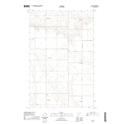
2020 Map of Volt
USGS Topo · Published 2020About this map
Volt sits at the southern edge of this landscape, a remote point of interest within the vast drylands of northeast Montana. The area is defined by the Tule Valley drainage system, where the seasonal flows of Tule Cr and the N Fork Tule Cr have carved a complex network of coulees and breaks. This 2020 survey reveals a sparse settlement pattern dominated by a strict grid of section lines and gravel access roads like Lustre Rd and Powder River Rd. The presence of Wall St and Fas 250 amidst the rangeland suggests the persistent infrastructure required to support the isolated agricultural and ranching operations of Roosevelt County. The map provides a clear record of modern land divisions across townships such as t31n r46e and t32n r47e, documenting the intersection of natural drainage and human organization in the Great Plains.
Find a feature on this map
23 named features on this map. Tap any name to fly to it.
Don’t see what you’re looking for? This feature index may not catch every label — zoom into the map to look around manually.
Map Details
Editions of this 2020 Volt Map
This is the sole edition of this map. No revisions or reprints were ever made.
Other maps of this area

1910 · Todd Lakes
USGS Topo · 1:62,500

1915 · Tule Valley
USGS Topo · 1:62,500

1915 · Todd Lakes
USGS Topo · 1:62,500

1954 · Wolf Point
USGS Topo · 1:250,000

1958 · Wolf Point
USGS Topo · 1:250,000

1973 · Peerless 4 SE
USGS Topo · 1:24,000

1973 · Peerless 4 SW
USGS Topo · 1:24,000

1973 · Poplar Coulee
USGS Topo · 1:24,000
1983 · Todd Lakes NE
USGS Topo · 1:24,000
1983 · Tule Valley East
USGS Topo · 1:24,000