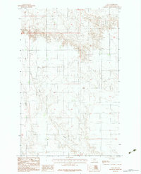
1983 Map of Volt
USGS Topo · Published 1983About this map
Volt serves as a central reference point in this northeastern Montana landscape, situated within the Fort Peck Indian Reservation as of the early 1980s. The terrain is defined by the winding course of Tule Creek, which cuts through the quadrangle and provides a focal point for the surrounding prairie. Evidence of local agricultural and industrial activity is scattered across the sheet, including a Grain Bin and a Gravel Pit. Genealogists may find value in the small Cem located near the southern border, marking a quiet point of historical record for local families. The map depicts a sparsely populated region where wide-open sections are occasionally punctuated by these small, essential landmarks of rural life.
Find a feature on this map
5 named features on this map. Tap any name to fly to it.
Don’t see what you’re looking for? This feature index may not catch every label — zoom into the map to look around manually.
Map Details
Editions of this 1983 Volt Map
This is the sole edition of this map. No revisions or reprints were ever made.
Other maps of this area

1910 · Todd Lakes
USGS Topo · 1:62,500

1915 · Tule Valley
USGS Topo · 1:62,500

1915 · Todd Lakes
USGS Topo · 1:62,500

1954 · Wolf Point
USGS Topo · 1:250,000

1958 · Wolf Point
USGS Topo · 1:250,000

1973 · Peerless 4 SE
USGS Topo · 1:24,000

1973 · Peerless 4 SW
USGS Topo · 1:24,000

1973 · Poplar Coulee
USGS Topo · 1:24,000
1983 · Todd Lakes NE
USGS Topo · 1:24,000
1983 · Tule Valley East
USGS Topo · 1:24,000