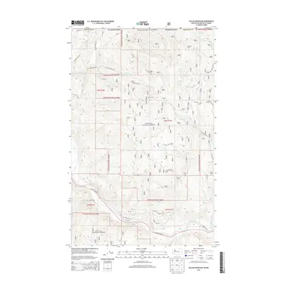
2014 Map of Vulcan Mountain
USGS Topo · Published 2014About this map
Vulcan Mtn and its strategic Vulcan Lookout dominate this high-country terrain within the Colville National Forest, just south of the Canadian border. The landscape is defined by the drainage systems of the Kettle River, which snakes across the southern portion of the map, and its many mountain tributaries including Catherine Cr and Goosmus Cr. This northern Ferry County region shows a network of forest access roads such as LaFleur Rd and Catherine Creek Rd, reflecting the active management of these timberlands. The presence of peaks like Snow Peak and Little Vulcan Mtn suggests a geography shaped by significant relief, providing a clear record of the watershed patterns that feed into the larger river valley at the base of the mountains.
Find a feature on this map
38 named features on this map. Tap any name to fly to it.
Don’t see what you’re looking for? This feature index may not catch every label — zoom into the map to look around manually.
Map Details
Editions of this 2014 Vulcan Mountain Map
This is the sole edition of this map. No revisions or reprints were ever made.
Other maps of this area

1904 · Republic
USGS Topo · 1:125,000

1948 · Curlew
USGS Topo · 1:62,500

1951 · Curlew
USGS Topo · 1:62,500

1951 · Bodie Mountain
USGS Topo · 1:62,500

1954 · Okanogan
USGS Topo · 1:250,000

1958 · Okanogan
USGS Topo · 1:250,000

1958 · Bodie Mtn
USGS Topo · 1:62,500

1984 · Republic
USGS Topo · 1:100,000
1988 · Curlew
USGS Topo · 1:24,000
1988 · Vulcan Mountain
USGS Topo · 1:24,000