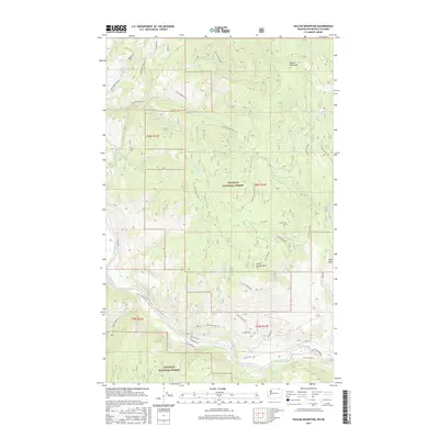
2017 Map of Vulcan Mountain
USGS Topo · Published 2017About this map
Vulcan Mountain and the surrounding heights of the Colville National Forest dominate this borderland landscape in Ferry County. The terrain is defined by a dense network of drainages including Catherine Cr, Goosmus Cr, and Tenas Mary Cr, which carve through the high country south of the international boundary. In the southern portion of the quadrangle, the Kettle River winds through the valley, flanked by rural routes like Kettle River Rd and Co Hwy 530. This 2017 survey illustrates the modern management of these timberlands, showing the complex web of forest access roads such as White Mountain Rd and Little Vulcan Rd that serve the area. Notable peaks like Little Vulcan Mtn and Snow Peak provide prominent landmarks for those studying the topography of the northern Okanogan Highlands.
Find a feature on this map
42 named features on this map. Tap any name to fly to it.
Don’t see what you’re looking for? This feature index may not catch every label — zoom into the map to look around manually.
Map Details
Editions of this 2017 Vulcan Mountain Map
This is the sole edition of this map. No revisions or reprints were ever made.
Other maps of this area

1904 · Republic
USGS Topo · 1:125,000

1948 · Curlew
USGS Topo · 1:62,500

1951 · Curlew
USGS Topo · 1:62,500

1951 · Bodie Mountain
USGS Topo · 1:62,500

1954 · Okanogan
USGS Topo · 1:250,000

1958 · Okanogan
USGS Topo · 1:250,000

1958 · Bodie Mtn
USGS Topo · 1:62,500

1984 · Republic
USGS Topo · 1:100,000
1988 · Curlew
USGS Topo · 1:24,000
1988 · Vulcan Mountain
USGS Topo · 1:24,000