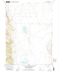
1966 Map of Vya
USGS Topo · Published 1982About this map
Vya serves as a lone reference point in this high-desert landscape of northwestern Nevada, situated at the edge of the expansive Long Valley (Depression). The terrain is defined by dry lake beds, including Fortynine Lake and Central Lake, which dominate the basin floor. To the west, the topography rises sharply toward North Bar Canyon, while the Black Hills provide a prominent boundary to the southeast. Water sources are scarce but critical, marked by a few Spring locations and drainage paths like Secret Creek and South Creek. Human activity is minimal, consisting primarily of remote trails, jeep trails, and localized Gravel Pits. This 1960s survey preserves the character of a region where the vast geologic basins of the Great Basin dictate the sparse patterns of transportation and resource extraction.
Find a feature on this map
17 named features on this map. Tap any name to fly to it.
Don’t see what you’re looking for? This feature index may not catch every label — zoom into the map to look around manually.
Map Details
Editions of this 1966 Vya Map
2 editions found
Other maps of this area

1889 · Long Valley
USGS Topo · 1:250,000

1954 · Vya
USGS Topo · 1:250,000

1958 · Vya
USGS Topo · 1:250,000

1962 · Vya
USGS Topo · 1:250,000

1966 · Massacre Lake NW
USGS Topo · 1:24,000

1966 · Vya
USGS Topo · 1:24,000
1966 · Carter Reservoir
USGS Topo · 1:24,000

1966 · Alkali Lake
USGS Topo · 1:24,000

1966 · Painted Point
USGS Topo · 1:24,000
1966 · Fortynine Mtn.
USGS Topo · 1:24,000