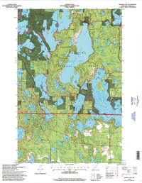
1996 Map of Wabana Lake
USGS Topo · Published 1998About this map
The Chippewa National Forest dominates this section of Itasca County, defined by a dense network of glacial lakes and managed timberlands. The Joyce Estate Historic Site is located along the western shore of the central water body, representing a significant piece of early twentieth-century resort history within the northern woods. To the west, the Suomi Hills Recreation Area provides a specialized landscape of ridges and depressions, while the Forest Management Area north of the historic site indicates active silviculture. Transport and recreation are intertwined via the Trout Lake Hiking Trail, which skirts the eastern margins. The map details a water-logged geography from Spider Lake in the north to the large expanse of Deer Lake in the south, interspersed with smaller features like the Tree Farm and local industrial traces such as a Gravel Pit.
Find a feature on this map
61 named features on this map. Tap any name to fly to it.
Don’t see what you’re looking for? This feature index may not catch every label — zoom into the map to look around manually.
Map Details
Editions of this 1996 Wabana Lake Map
This is the sole edition of this map. No revisions or reprints were ever made.
Other maps of this area

1919 · Release
USGS Topo · 1:62,500

1919 · Marcell
USGS Topo · 1:62,500

1920 · Trout Lake
USGS Topo · 1:62,500

1943 · Release
USGS Topo · 1:62,500

1952 · Bovey
USGS Topo · 1:24,000

1953 · Cohasset East
USGS Topo · 1:24,000

1953 · Cohasset West
USGS Topo · 1:24,000

1954 · Hibbing
USGS Topo · 1:250,000

1957 · Hibbing
USGS Topo · 1:250,000

1958 · Hibbing
USGS Topo · 1:250,000