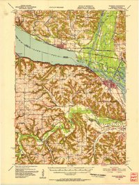
1951 Map of Wabasha
USGS Topo · Published 1953About this map
Lake Pepin dominates the northern half of this survey, where the Mississippi River widens between the steep bluffs of Wisconsin and Minnesota. This 1951 revision captures the river's complex network of backwaters and islands, including Wancoutah Island and Drury Island, just before the confluence with the Chippewa River. On the Wisconsin shore, the Chicago Burlington And Quincy RR traces the base of the bluffs through Stockholm, Lakeport, and Pepin, while the Minnesota side features the river towns of Lake City and Reads Landing.
Find a feature on this map
121 named features on this map. Tap any name to fly to it.
Don’t see what you’re looking for? This feature index may not catch every label — zoom into the map to look around manually.
Map Details
Editions of this 1951 Wabasha Map
3 editions found

Other maps of this area

1929 · Durand
USGS Topo · 1:62,500

1932 · Cochrane
USGS Topo · 1:62,500

1932 · Wabasha
USGS Topo · 1:62,500

1932 · Durand
USGS Topo · 1:62,500

1932 · Alma
USGS Topo · 1:62,500

1934 · Plainview
USGS Topo · 1:62,500

1934 · Cochrane
USGS Topo · 1:62,500

1935 · Rochester
USGS Topo · 1:48,000

1935 · Arkansaw
USGS Topo · 1:48,000

1937 · Cochrane
USGS Topo · 1:62,500