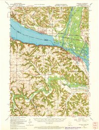
1951 Map of Wabasha
USGS Topo · Published 1972About this map
Lake Pepin dominates this mid-century survey, acting as a natural widening of the Mississippi River that defines the border between Wisconsin and Minnesota. The riverfront economy and transit patterns of the early 1950s are evident in the density of rail lines, with the Burlington Northern and the Chicago Milwaukee St Paul and Pacific tracing the water's edge on either side. Near the confluence of the Chippewa River and the Mississippi, the village of Reads Landing sits across from the river delta's intricate network of sloughs, including Battle Slough and Indian Slough.
Find a feature on this map
99 named features on this map. Tap any name to fly to it.
Don’t see what you’re looking for? This feature index may not catch every label — zoom into the map to look around manually.
Map Details
Editions of this 1951 Wabasha Map
3 editions found

Other maps of this area

1929 · Durand
USGS Topo · 1:62,500

1932 · Cochrane
USGS Topo · 1:62,500

1932 · Wabasha
USGS Topo · 1:62,500

1932 · Durand
USGS Topo · 1:62,500

1932 · Alma
USGS Topo · 1:62,500

1934 · Plainview
USGS Topo · 1:62,500

1934 · Cochrane
USGS Topo · 1:62,500

1935 · Rochester
USGS Topo · 1:48,000

1935 · Arkansaw
USGS Topo · 1:48,000

1937 · Cochrane
USGS Topo · 1:62,500