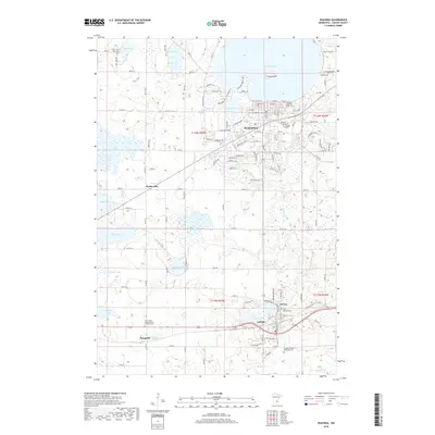
2019 Map of Waconia
USGS Topo · Published 2019About this map
Waconia sits at the southern edge of the expansive Lake Waconia, characterized by a landscape where glacial depressions have created a dense network of water bodies including Burandt Lake, Hydes Lake, and Meuwissen Lake. The transition from the established street grids of Waconia and Cologne to the surrounding agricultural sections is marked by numerous family and community landmarks. Genealogists will find a high density of burial sites across the township lines of t116n r25w and t116n r24w, such as Lakeview Waconia Public Cem and the Saint John's United Church of Christ Cem. The southern half of the map is defined by the winding course of Carver Creek and Bevens Creek, which drain the lowlands between the small settlements of Benton and Bongards. This 2019 survey documents the modern layout of these Carver County communities while preserving the locations of historical rural cemeteries and the unique landmark of Coney Island in the center of the lake.
Find a feature on this map
129 named features on this map. Tap any name to fly to it.
Don’t see what you’re looking for? This feature index may not catch every label — zoom into the map to look around manually.
Map Details
Editions of this 2019 Waconia Map
This is the sole edition of this map. No revisions or reprints were ever made.
Other maps of this area

1905 · Minnetonka
USGS Topo · 1:62,500

1907 · Minnetonka
USGS Topo · 1:62,500

1953 · Saint Paul
USGS Topo · 1:250,000

1957 · Belle Plaine
USGS Topo · 1:62,500

1957 · Waconia
USGS Topo · 1:62,500

1957 · New Prague
USGS Topo · 1:62,500

1958 · Victoria
USGS Topo · 1:24,000

1958 · Mound
USGS Topo · 1:24,000

1958 · Lake Minnetonka
USGS Topo · 1:62,500

1959 · Saint Paul
USGS Topo · 1:250,000