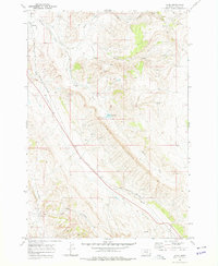
1969 Map of Wade
USGS Topo · Published 1978About this map
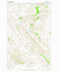
Wade serves as a central point along the Burlington Northern railroad in this Carbon County landscape, where the rail line follows the natural corridor created by Jack Creek. The map documents a rugged terrain shaped by the South Fork and the North Fork of Bridger Creek, illustrating a transition from early pioneer settlement to industrial development. Isolated dwellings such as Parker Cabin and Baker Cabin are recorded alongside signs of extractive enterprise, including a Mine and various Prospect locations. Water management is a visible priority for this arid environment, evidenced by the presence of Mutual Ditch and the Depression Reservoir with its associated Spillway. The infrastructure of the era is further marked by a prominent Pipeline traversing the southern portion of the quadrangle near the settlement of Castle.
Find a feature on this map
25 named features on this map. Tap any name to fly to it.
Don’t see what you’re looking for? This feature index may not catch every label — zoom into the map to look around manually.
Map Details
Editions of this 1969 Wade Map
2 editions found
Other maps of this area

1954 · Billings
USGS Topo · 1:250,000

1956 · Bridger
USGS Topo · 1:24,000

1957 · Billings
USGS Topo · 1:250,000

1958 · Billings
USGS Topo · 1:250,000

1967 · Section House Draw
USGS Topo · 1:24,000

1967 · Bluewater
USGS Topo · 1:24,000

1969 · Warren
USGS Topo · 1:24,000

1969 · Bowler
USGS Topo · 1:24,000
1969 · Hatcher Pass
USGS Topo · 1:24,000
1969 · Hunters Creek
USGS Topo · 1:24,000