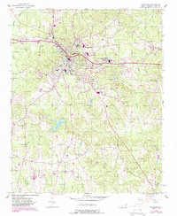
1956 Map of Wadesboro
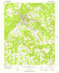
USGS Topo · Published 1988About this map
Wadesboro serves as the focal point of this mid-century North Carolina landscape, where the town's grid meets a radial network of roads and rail lines. Industry and community life are visible through sites like Wade Mills and the County Home, while the surrounding Anson County countryside is dotted with a high density of rural religious centers, including Hanna Ch, Mt Beulah Ch, and Pleasant Hill Ch.
Find a feature on this map
42 named features on this map. Tap any name to fly to it.
Don’t see what you’re looking for? This feature index may not catch every label — zoom into the map to look around manually.
Map Details
Editions of this 1956 Wadesboro Map
3 editions found

Other maps of this area

1941 · Spartanburg
USGS Topo · 1:250,000

1942 · Troy
USGS Topo · 1:125,000

1942 · Rockingham
USGS Topo · 1:125,000

1953 · Florence
USGS Topo · 1:250,000

1953 · Raleigh
USGS Topo · 1:250,000

1953 · Spartanburg
USGS Topo · 1:250,000

1953 · Charlotte
USGS Topo · 1:250,000

1954 · Charlotte
USGS Topo · 1:250,000

1954 · Florence
USGS Topo · 1:250,000

1954 · Raleigh
USGS Topo · 1:250,000