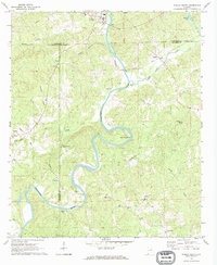
1969 Map of Wadley South
USGS Topo · Published 1973About this map
The Tallapoosa River carves a dramatic path through the landscape of Chambers County, most notably at the sweeping turn of Muleshoe Bend. This late-1960s environment is defined by its small rural crossroads and river-dependent topography, featuring uniquely named settlements like Frog Eye and the river crossing at Bibbys Ferry. The Seaboard Coast Line railroad runs parallel to the river corridor, supporting local communities such as Abanda and Wadley. Numerous spiritual and communal landmarks dot the terrain, including Antioch Ch, Ebenezer Ch, and Shiloh. The geography is further characterized by its dense network of tributaries, including Chikasanoxee Creek and High Pine Creek, which historically dictated the placement of schools like the High Sch and several small Gravel Pits that suggest local industry in this transitional period.
Find a feature on this map
36 named features on this map. Tap any name to fly to it.
Don’t see what you’re looking for? This feature index may not catch every label — zoom into the map to look around manually.
Map Details
Editions of this 1969 Wadley South Map
This is the sole edition of this map. No revisions or reprints were ever made.
Other maps of this area

1891 · Ashland
USGS Topo · 1:125,000

1899 · Wedowee
USGS Topo · 1:125,000

1902 · Wedowee
USGS Topo · 1:125,000

1906 · Dadeville
USGS Topo · 1:125,000

1907 · Opelika
USGS Topo · 1:125,000

1909 · Opelika
USGS Topo · 1:125,000

1953 · Atlanta
USGS Topo · 1:250,000

1955 · Phenix City
USGS Topo · 1:250,000

1957 · Phenix City
USGS Topo · 1:250,000

1957 · Atlanta
USGS Topo · 1:250,000