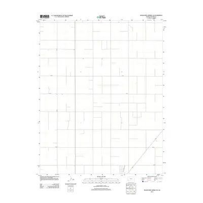
2012 Map of Wagon Bed Spring SE
USGS Topo · Published 2012About this map
Agricultural grid lines define this corner of Stevens County, Kansas, where the high plains landscape is segmented into precise sections. This survey reveals a terrain dominated by an orderly network of rural transport, centered on the intersection of Road 2 and 1mi Rd. Unlike many early maps that trace natural contours or meandering paths, the development here follows the rigid Jeffersonian grid system, creating a landscape of right angles and long, straight thoroughfares such as Road Y and Road V. In the southeastern portion of the quadrangle, 6mi Rd intersects a state highway, marking one of the few diagonal breaks in the otherwise uniform regional layout. The sparsity of named settlements or vertical landmarks reflects the specialized land use of the High Plains in the early twenty-first century, where infrastructure is designed primarily for industrial-scale farming and local connectivity.
Find a feature on this map
5 named features on this map. Tap any name to fly to it.
Don’t see what you’re looking for? This feature index may not catch every label — zoom into the map to look around manually.
Map Details
Editions of this 2012 Wagon Bed Spring SE Map
This is the sole edition of this map. No revisions or reprints were ever made.
Other maps of this area

1944 · Moscow
USGS Topo · 1:62,500

1945 · Moscow
USGS Topo · 1:62,500

1955 · Dodge City
USGS Topo · 1:250,000

1958 · Dodge City
USGS Topo · 1:250,000

1959 · Dodge City
USGS Topo · 1:250,000

1974 · Hugoton
USGS Topo · 1:24,000

1974 · Feterita
USGS Topo · 1:24,000
1974 · Wagon Bed Spring NW
USGS Topo · 1:24,000
1974 · Wagon Bed Spring SW
USGS Topo · 1:24,000
1974 · Wagon Bed Spring
USGS Topo · 1:24,000