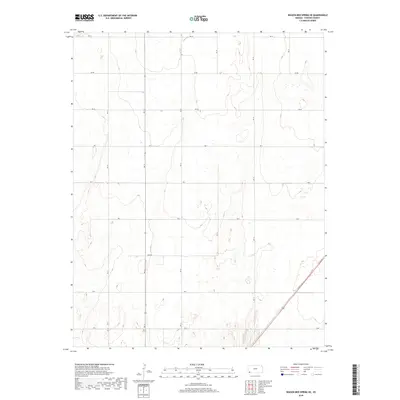
2018 Map of Wagon Bed Spring SE
USGS Topo · Published 2018About this map
The high plains of Stevens County are defined by a rigorous section-line road network in this modern topographic study. Organized under the Public Land Survey System, the landscape is partitioned into townships including t31s r37w, t31s r36w, t32s r37w, and t32s r36w. The terrain is marked by subtle depressions and ephemeral wetland pockets, reflecting the semi-arid character of western Kansas. This survey details a strictly functional infrastructure where local routes like Rd Cc and Rd Bb form the primary corridors for agricultural transport. A single diagonal highway cuts across the southeast corner, providing a stark contrast to the rigid grid established by roads such as Rd Z and Road W. The map documents a sparsely populated rural area where the economy remains deeply tied to the underlying geography and large-scale land management.
Find a feature on this map
20 named features on this map. Tap any name to fly to it.
Don’t see what you’re looking for? This feature index may not catch every label — zoom into the map to look around manually.
Map Details
Editions of this 2018 Wagon Bed Spring SE Map
This is the sole edition of this map. No revisions or reprints were ever made.
Other maps of this area

1944 · Moscow
USGS Topo · 1:62,500

1945 · Moscow
USGS Topo · 1:62,500

1955 · Dodge City
USGS Topo · 1:250,000

1958 · Dodge City
USGS Topo · 1:250,000

1959 · Dodge City
USGS Topo · 1:250,000

1974 · Hugoton
USGS Topo · 1:24,000

1974 · Feterita
USGS Topo · 1:24,000
1974 · Wagon Bed Spring NW
USGS Topo · 1:24,000
1974 · Wagon Bed Spring SW
USGS Topo · 1:24,000
1974 · Wagon Bed Spring
USGS Topo · 1:24,000