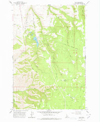
1968 Map of Waha
USGS Topo · Published 1978About this map
Lake Waha and the small settlement of Waha anchor the northwestern portion of this 1968 survey in Nez Perce County. The landscape is defined by the significant Nez Perce Indian Reservation Boundary, which cuts across the high terrain of Simons Ridge and Craig Mountain. The map reveals a specialized land use pattern near the lakes, including a Fish Hatchery, Gravel Pit, and various springs, suggesting a localized economy focused on natural resources and early recreation.
Find a feature on this map
22 named features on this map. Tap any name to fly to it.
Don’t see what you’re looking for? This feature index may not catch every label — zoom into the map to look around manually.
Map Details
Editions of this 1968 Waha Map
2 editions found
Other maps of this area

1946 · Limekiln Rapids
USGS Topo · 1:62,500

1955 · Pullman
USGS Topo · 1:250,000

1958 · Pullman
USGS Topo · 1:250,000

1958 · Sweetwater
USGS Topo · 1:24,000

1958 · Lewiston Orchards South
USGS Topo · 1:24,000

1958 · Lewiston Orchards
USGS Topo · 1:62,500

1958 · Culdesac
USGS Topo · 1:62,500

1967 · Hoover Point
USGS Topo · 1:24,000

1968 · Waha
USGS Topo · 1:24,000
1968 · Winchester West
USGS Topo · 1:24,000