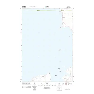
2013 Map of Wahkon North
USGS Topo · Published 2013About this map
Wahkon sits at the southern edge of this map, serving as the primary hub for the shoreline along Mille Lacs Lake. The expansive waters of the lake dominate the central area, dotted with small landmarks like Hennepin Island and the Upper Twin and Lower Twin Islands. Along the southern coast, the local geography is defined by a mix of residential roads and community institutions, including the Galloway Youth Camp. The northern shoreline features prominent geographic markers such as Hunters Point and Big Point, where MN-18 follows the curve of the lake toward the Aitkin County line. This area illustrates the specialized landscape of a Minnesota lake community, where the land is primarily organized around access to the water, shown through features like Spider Island and the numerous small bays and points that define the coast near Pope Point.
Find a feature on this map
30 named features on this map. Tap any name to fly to it.
Don’t see what you’re looking for? This feature index may not catch every label — zoom into the map to look around manually.
Map Details
Editions of this 2013 Wahkon North Map
This is the sole edition of this map. No revisions or reprints were ever made.
Other maps of this area

1916 · Wealthwood
USGS Topo · 1:62,500

1953 · Duluth
USGS Topo · 1:250,000

1958 · Duluth
USGS Topo · 1:250,000

1968 · Onamia NW
USGS Topo · 1:24,000

1968 · Onamia
USGS Topo · 1:24,000

1968 · Isle SW
USGS Topo · 1:24,000

1968 · Wahkon North
USGS Topo · 1:24,000

1968 · Isle
USGS Topo · 1:24,000
1968 · Wahkon South
USGS Topo · 1:24,000

1969 · Thor SW
USGS Topo · 1:24,000
Featured Places
- Wahkon, MN
- South Harbor Township, MN
- East Side Township, MN
- Isle Harbor Township, MN
- Mille Lacs County, MN