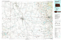
1985 Map of Wahpeton
USGS Topo · Published 1989About this map
The Red River of the North defines the border between North Dakota and Minnesota, acting as the central axis for this mid-1980s topographic survey. This region, where the Otter Tail River and Bois de Sioux River converge to form the Red River, is characterized by its heavy concentration of water management and wildlife conservation areas, such as the Orwell State Wildlife Management Area and the Lake Elsie National Wildlife Refuge. The map captures the twin cities of Wahpeton and Breckenridge at a time of established rail and highway infrastructure, including several specialized landing strips like Bagg Landing Field and the Yaggie Landing Strip. Historically significant sites like Fort Abercrombie State Park sit alongside smaller agricultural hubs like Hankinson, Fairmount, and Abercrombie. The landscape is a patchwork of waterfowl production areas and state wildlife management zones, reflecting a managed prairie environment just east of the Sheyenne National Grassland.
Find a feature on this map
147 named features on this map. Tap any name to fly to it.
Don’t see what you’re looking for? This feature index may not catch every label — zoom into the map to look around manually.
Map Details
Editions of this 1985 Wahpeton Map
2 editions found
Other maps of this area

1895 · Fargo
USGS Topo · 1:125,000

1895 · Casselton
USGS Topo · 1:125,000

1897 · Fargo
USGS Topo · 1:125,000

1897 · Casselton
USGS Topo · 1:125,000

1904 · Wahpeton
USGS Topo · 1:125,000

1907 · Wyndmere
USGS Topo · 1:125,000

1910 · Wendell
USGS Topo · 1:62,500

1911 · Barrett
USGS Topo · 1:62,500

1911 · Herman
USGS Topo · 1:62,500

1912 · Vergas
USGS Topo · 1:62,500