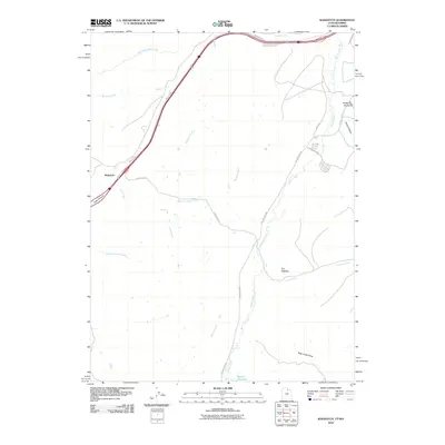
2010 Map of Wahsatch
USGS Topo · Published 2010About this map
Wahsatch sits at the western edge of this High Plains landscape, where the transit corridors of modern infrastructure follow the ancient logic of the terrain. The settlement is positioned near the head of Echo Canyon, a critical passage that has historically funneled travelers toward the Great Salt Lake Valley. The topography is defined by a series of drainages, including Wasatch Creek and Yellow Creek, which carve through the high ground. Distinctive landforms such as The Needles and Sage Creek Draw provide clear landmarks for those navigating the area south of the Wyoming-Utah border. In the southern portion of the quadrangle, Barker Reservoir and Yellow Creek RD indicate the persistent utility of this water-scarce environment, while names like Slaughterhouse Creek and Suttons Creek hint at the ranching and local history of the Uinta County region.
Find a feature on this map
20 named features on this map. Tap any name to fly to it.
Don’t see what you’re looking for? This feature index may not catch every label — zoom into the map to look around manually.
Map Details
Editions of this 2010 Wahsatch Map
This is the sole edition of this map. No revisions or reprints were ever made.
Other maps of this area

1954 · Ogden
USGS Topo · 1:250,000

1958 · Ogden
USGS Topo · 1:250,000

1960 · Ogden
USGS Topo · 1:250,000

1965 · Evanston
USGS Topo · 1:24,000

1965 · Myers Reservoir
USGS Topo · 1:24,000

1965 · Millis
USGS Topo · 1:24,000

1968 · Wahsatch
USGS Topo · 1:24,000
1968 · Porcupine Ridge
USGS Topo · 1:24,000

1968 · Shearing Corral
USGS Topo · 1:24,000

1968 · Mc Kay Hollow
USGS Topo · 1:24,000