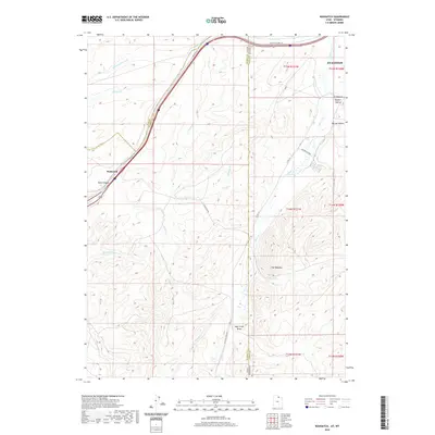
2020 Map of Wahsatch
USGS Topo · Published 2020About this map
Wahsatch sits at a critical junction of transport and topography along the Utah-Wyoming border. This high-country landscape is defined by the historic passage through Echo Canyon, where modern infrastructure follows the same natural corridor used by the Lincoln Highway 30. The map documents the transition from the rugged drainage of Echo Cr in the west to the high plateau country of Evanston in the northeast. Striking geological features like The Needles and numerous named draws such as Sage Creek Draw characterize this divide. The survey captures the network of ranching roads, including Wasatch Rd and Pvt Ranch Rd, that connect isolated hollows like Sulphur Hollow and Burton Hollow to the larger regional centers. For those tracing the evolution of western transit, the alignment of roads and waterways like Yellow Cr provides a clear view of how the land dictates the path of commerce and movement.
Find a feature on this map
31 named features on this map. Tap any name to fly to it.
Don’t see what you’re looking for? This feature index may not catch every label — zoom into the map to look around manually.
Map Details
Editions of this 2020 Wahsatch Map
This is the sole edition of this map. No revisions or reprints were ever made.
Other maps of this area

1954 · Ogden
USGS Topo · 1:250,000

1958 · Ogden
USGS Topo · 1:250,000

1960 · Ogden
USGS Topo · 1:250,000

1965 · Evanston
USGS Topo · 1:24,000

1965 · Myers Reservoir
USGS Topo · 1:24,000

1965 · Millis
USGS Topo · 1:24,000

1968 · Wahsatch
USGS Topo · 1:24,000
1968 · Porcupine Ridge
USGS Topo · 1:24,000

1968 · Shearing Corral
USGS Topo · 1:24,000

1968 · Mc Kay Hollow
USGS Topo · 1:24,000