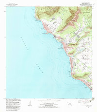
1983 Map of Waianae
USGS Topo · Published 1983About this map
Ancient Kaneaki Heiau and several other archaeological sites including Petroglyphs and the Kaneilio Point Heiau (Site) anchor the cultural landscape of the Leeward Coast in the early 1980s. The transition from the steep ridges of the Makaha Forest Reserve and Waianae Kai Forest Reserve down to the beach-fronted settlements of Makaha and Waianae is clearly defined. This era shows the developed valley floors occupied by Waianae Homesteads and Lualualei Homesteads, indicating a stable residential and agricultural pattern. Significant military infrastructure is present, notably the U S Naval Transmitting Facility, which occupies a large portion of the coastal plain south of Maili. The coastal corridor is dominated by a string of recreation areas such as Maili Beach Park and Nanakuli Beach Park, illustrating the importance of the shoreline to the local community's social and recreational life.
Find a feature on this map
64 named features on this map. Tap any name to fly to it.
Don’t see what you’re looking for? This feature index may not catch every label — zoom into the map to look around manually.
Map Details
Editions of this 1983 Waianae Map
2 editions found
Other maps of this area

1953 · Haleiwa
USGS Topo · 1:24,000

1953 · Schofield Barracks
USGS Topo · 1:24,000

1953 · Ewa
USGS Topo · 1:24,000

1954 · Oahu
USGS Topo · 1:250,000

1954 · Waianae
USGS Topo · 1:24,000

1954 · Kaena
USGS Topo · 1:24,000

1960 · Haleiwa
USGS Topo · 1:24,000

1960 · Schofield Barracks
USGS Topo · 1:24,000

1961 · Oahu
USGS Topo · 1:250,000
1962 · Ewa
USGS Topo · 1:24,000