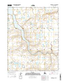
2014 Map of Wainwright C-1 NE
USGS Topo · Published 2014About this map
The Kugrua River winds through this Arctic coastal plain in a complex series of tight meanders and oxbow lakes, illustrating the dynamic hydrology of the North Slope. This landscape is characterized by its low-lying topography and thousands of small, unmapped thaw lakes that dominate the terrain between the primary watercourses. Apart from the main channel of the river, Avgunun Cr enters the northwestern corner of the quadrangle, draining a region shaped by seasonal permafrost cycles. The lack of man-made structures or improved roads underscores the isolation of this environment, where the natural drainage patterns of the Kugrua River remain the most significant geographical markers for navigation and land use study.
Find a feature on this map
6 named features on this map. Tap any name to fly to it.
Don’t see what you’re looking for? This feature index may not catch every label — zoom into the map to look around manually.
Map Details
Editions of this 2014 Wainwright C-1 NE Map
This is the sole edition of this map. No revisions or reprints were ever made.
Other maps of this area

1951 · Meade River
USGS Topo · 1:250,000

1951 · Wainwright
USGS Topo · 1:250,000

1955 · Wainwright
USGS Topo · 1:250,000

1955 · Meade River
USGS Topo · 1:250,000

1955 · Wainwright C-1
USGS Topo · 1:63,360

1955 · Meade River D-5
USGS Topo · 1:63,360

1955 · Meade River C-5
USGS Topo · 1:63,360
1955 · Wainwright D-1
USGS Topo · 1:63,360
1962 · Meade River C-5
USGS Topo · 1:50,000
1962 · Meade River D-5
USGS Topo · 1:50,000