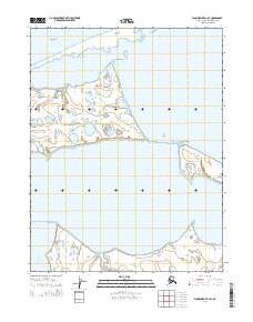
2014 Map of Wainwright D-1 SE
USGS Topo · Published 2014About this map
The Chukchi Sea coastline defines this portion of the North Slope, where the arctic landscape is dominated by a complex network of coastal lagoons and shifting barrier landforms. The map illustrates the specialized geography of Peard Bay and the more southern Kugrua Bay, which is fed by the meandering Kugrua River. These protected waters and prominent landforms such as Asiniak Point and Eluksingiak Point have long served as essential navigation and subsistence landmarks for travelers and hunters along the Arctic coast. The intricate hydrography of the interior sections reveals countless small ponds and wetlands, characteristic of the permafrost-rich terrain within the t17n r28w and t16n r28w township boundaries. This coastal survey documents the precise shape of the Alaskan shoreline before the accelerating impacts of modern erosion and sea-level change.
Find a feature on this map
12 named features on this map. Tap any name to fly to it.
Don’t see what you’re looking for? This feature index may not catch every label — zoom into the map to look around manually.
Map Details
Editions of this 2014 Wainwright D-1 SE Map
This is the sole edition of this map. No revisions or reprints were ever made.
Other maps of this area

1951 · Meade River
USGS Topo · 1:250,000

1951 · Wainwright
USGS Topo · 1:250,000

1955 · Wainwright
USGS Topo · 1:250,000

1955 · Meade River
USGS Topo · 1:250,000

1955 · Wainwright C-1
USGS Topo · 1:63,360

1955 · Meade River D-5
USGS Topo · 1:63,360

1955 · Meade River C-5
USGS Topo · 1:63,360
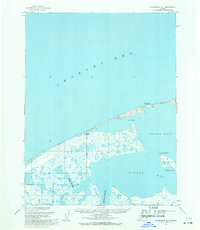
1955 · Wainwright D-1
USGS Topo · 1:63,360
1962 · Meade River C-5
USGS Topo · 1:50,000
1962 · Meade River D-5
USGS Topo · 1:50,000