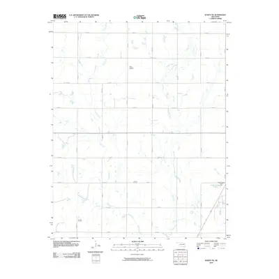
2009 Map of Wakita SE
USGS Topo · Published 2009About this map
Saint Anthony Cemetery and Fairview Cemetery sit among the section-line roads of Grant County, marking the long-established burial grounds of this agricultural landscape. The area is defined by a grid of local routes like E0130 Rd and N2910 Rd, which cut across the natural winding paths of Pond Creek and Osage Creek. In the southeast, industrial land use is evident near Koch Holding Pond A, where a dammed feature interrupts the typical prairie drainage patterns. Further south, Klondike Cemetery serves as another focal point for local history, located near the confluence of several small tributaries. This 2009 survey illustrates a region where the traditional cemetery locations and the rigid township and range road system remain the primary landmarks across the drainage basins of Boggey Creek and its neighboring waterways.
Find a feature on this map
22 named features on this map. Tap any name to fly to it.
Don’t see what you’re looking for? This feature index may not catch every label — zoom into the map to look around manually.
Map Details
Editions of this 2009 Wakita SE Map
This is the sole edition of this map. No revisions or reprints were ever made.
Other maps of this area

1955 · Enid
USGS Topo · 1:250,000

1958 · Enid
USGS Topo · 1:250,000

1968 · Lamont NW
USGS Topo · 1:24,000

1968 · Wakita
USGS Topo · 1:24,000

1968 · Wakita SE
USGS Topo · 1:24,000

1968 · Renfrow
USGS Topo · 1:24,000

1968 · Medford
USGS Topo · 1:24,000

1968 · Pond Creek
USGS Topo · 1:24,000

1968 · Pond Creek NW
USGS Topo · 1:24,000
1968 · Wakita NE
USGS Topo · 1:24,000