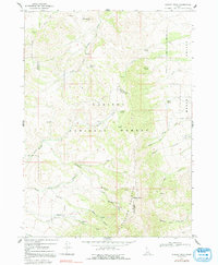
1968 Map of Wakley Peak
USGS Topo · Published 1992About this map
Caribou National Forest dominates this mountain landscape along the border of Oneida and Bannock Counties, where high ridges separate several prominent drainages. Rising to the east, Elkhorn Mountain and its summit at Wakley Peak overlook a complex network of canyons, including Farmers Canyon, Reed Canyon, and Rowley Canyon. The presence of scattered Mines and Prospects near the headwaters of Hawkins Creek and Wright Creek suggests a history of mineral exploration throughout these highlands. To the east, the terrain descends into Marsh Valley, where Marsh Creek flows north. This 1968 field check captures the area's transition from high-altitude springs and creek forks, such as the South Fork Hawkins Creek, to the developed roads of the valley floor like Reese Creek Rd and Wakley Rd.
Find a feature on this map
35 named features on this map. Tap any name to fly to it.
Don’t see what you’re looking for? This feature index may not catch every label — zoom into the map to look around manually.
Map Details
Editions of this 1968 Wakley Peak Map
2 editions found
Other maps of this area

1954 · Pocatello
USGS Topo · 1:250,000

1958 · Pocatello
USGS Topo · 1:250,000

1963 · Daniels
USGS Topo · 1:24,000

1968 · Daniels
USGS Topo · 1:24,000

1968 · Malad Summit
USGS Topo · 1:24,000

1968 · Dairy Creek
USGS Topo · 1:24,000

1968 · Downey West
USGS Topo · 1:24,000

1968 · Wakley Peak
USGS Topo · 1:24,000
1968 · Elkhorn Peak
USGS Topo · 1:24,000

1968 · Hawkins
USGS Topo · 1:24,000