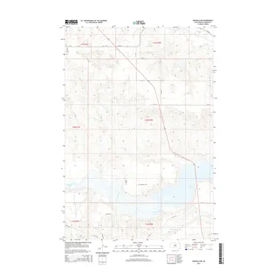
2015 Map of Wakpala NW
USGS Topo · Published 2015About this map
Lake Oahe and the lower reach of the Grand River dominate this Corson County landscape, illustrating the geography of the Standing Rock Reservation area in the early 21st century. The map highlights significant local landmarks such as Sacred Heart Cem and Long Hill Cem, which are situated on the northern bluffs overlooking the river valley. The terrain transitions from the low-lying shoreline of the reservoir to the elevated peaks of the Kline Buttes in the northwest. This survey details a network of rural and Bureau of Indian Affairs routes, including Bia RD 44 and Bia RD 10, alongside smaller watercourses like Oak Cr and Deep Bank Cr. The grid of section lines and township boundaries, such as t20n r28e, provides a clear spatial framework for the sparse homesteads and grazing lands of this prairie region.
Find a feature on this map
21 named features on this map. Tap any name to fly to it.
Don’t see what you’re looking for? This feature index may not catch every label — zoom into the map to look around manually.
Map Details
Editions of this 2015 Wakpala NW Map
This is the sole edition of this map. No revisions or reprints were ever made.
Other maps of this area

1953 · McIntosh
USGS Topo · 1:250,000

1956 · Wakpala NW
USGS Topo · 1:24,000

1956 · Little Eagle
USGS Topo · 1:24,000

1956 · Wakpala SE
USGS Topo · 1:24,000

1956 · Little Eagle SE
USGS Topo · 1:24,000

1956 · Wakpala SW
USGS Topo · 1:24,000

1956 · Wakpala
USGS Topo · 1:24,000

1958 · McIntosh
USGS Topo · 1:250,000

1966 · McLaughlin
USGS Topo · 1:24,000

1966 · Mahto
USGS Topo · 1:24,000