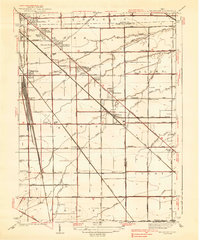
1938 Map of Walbridge
USGS Topo · Published 1938About this map
The heavy industrial and agricultural landscape south of Lake Erie is defined by a dense concentration of rail infrastructure, most notably the massive Walbridge Yard and the crossing of the Chesapeake and Ohio RR, Pennsylvania RR, and the New York Central Road. This 1930s landscape reveals a mix of established rail-stop settlements like Millbury and Latchie alongside optimistic residential developments such as Biltmore Gardens and Brighton Gardens. The map provides an important look at the early Toledo Airport and rural landmarks like the Black Swamp and Cresceus Farms. Genealogists will find value in the specific locations of the Lake Cem and Allen Cem, as well as neighborhood institutions including Grant Sch and Little Crane Sch. This survey documents a critical period when the region's transport network was shifting from steam rail to early aviation and highway travel.
Find a feature on this map
60 named features on this map. Tap any name to fly to it.
Don’t see what you’re looking for? This feature index may not catch every label — zoom into the map to look around manually.
Map Details
Editions of this 1938 Walbridge Map
2 editions found

Other maps of this area

1900 · Maumee Bay
USGS Topo · 1:62,500

1900 · Toledo
USGS Topo · 1:62,500

1901 · Bowling Green
USGS Topo · 1:62,500

1901 · Elmore
USGS Topo · 1:62,500

1903 · Bowling Green
USGS Topo · 1:62,500

1903 · Elmore
USGS Topo · 1:62,500

1934 · Reno Beach
USGS Topo · 1:24,000

1934 · Point Place
USGS Topo · 1:24,000

1934 · Rossford
USGS Topo · 1:24,000

1935 · Walbridge
USGS Topo · 1:24,000