
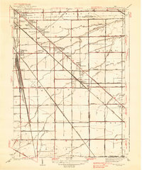
1938 Map of Walbridge
USGS Topo · Published 1938About this map
The expansive Walbridge Yard serves as a massive industrial anchor in this 1930s landscape, illustrating the critical rail infrastructure of Northwest Ohio. The confluence of the Pennsylvania RR, Chesapeake and Ohio RR, and the Terminal RR defines the western edge of the quadrangle, facilitating the movement of goods through the region. Surrounding this transit hub, a series of residential and agricultural developments like Biltmore Gardens, Brighton Gardens, and Mound View emerge along the Woodville Road corridor.
Find a feature on this map
69 named features on this map. Tap any name to fly to it.
Don’t see what you’re looking for? This feature index may not catch every label — zoom into the map to look around manually.
Map Details
Editions of this 1938 Walbridge Map
2 editions found
Other maps of this area

1900 · Maumee Bay
USGS Topo · 1:62,500

1900 · Toledo
USGS Topo · 1:62,500

1901 · Bowling Green
USGS Topo · 1:62,500

1901 · Elmore
USGS Topo · 1:62,500

1903 · Bowling Green
USGS Topo · 1:62,500

1903 · Elmore
USGS Topo · 1:62,500

1934 · Reno Beach
USGS Topo · 1:24,000

1934 · Point Place
USGS Topo · 1:24,000

1934 · Rossford
USGS Topo · 1:24,000

1935 · Walbridge
USGS Topo · 1:24,000