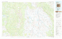
1981 Map of Walden
USGS Topo · Published 1982About this map
The Continental Divide winds through this high-altitude landscape of North Park, defining a region where the North Platte River and its major tributaries—the Michigan River, Illinois River, and Canadian River—converge. As of the early 1980s, the town of Walden stands as the central hub of this mountain basin, flanked by the Medicine Bow Mountains to the east and the Park Range to the west. The local economy is traced through the Union Pacific rail line and specific industrial sites like the Routt County Coal Mine and Sudduth Mine.
Find a feature on this map
67 named features on this map. Tap any name to fly to it.
Don’t see what you’re looking for? This feature index may not catch every label — zoom into the map to look around manually.
Map Details
Editions of this 1981 Walden Map
This is the sole edition of this map. No revisions or reprints were ever made.
Other maps of this area

1895 · Laramie
USGS Topo · 1:125,000

1902 · Laramie
USGS Topo · 1:125,000

1905 · Laramie
USGS Topo · 1:125,000

1906 · Medicine Bow
USGS Topo · 1:125,000

1906 · Laramie
USGS Topo · 1:125,000

1908 · Laramie
USGS Topo · 1:125,000

1908 · Medicine Bow
USGS Topo · 1:125,000

1911 · Hahns Peak
USGS Topo · 1:125,000

1913 · Hahns Peak
USGS Topo · 1:125,000

1915 · Longs Peak
USGS Topo · 1:125,000