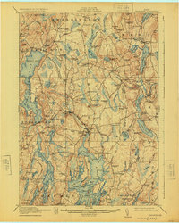
1915 Map of Waldoboro
USGS Topo · Published 1925About this map
The Medomak River and St. George River dominate this coastal Maine landscape, shaping the development of Waldoboro and surrounding townships just before the mid-1920s. The map reveals a high density of rural infrastructure, from the Maine Central Railroad stopping at Glendon Station and Nobleboro Station to the numerous one-room schoolhouses such as Nye School, Slaigo School, and Duckpuddle School. This survey captures the region's mid-coast transition, where inland farming at North Waldoboro and Stickney Corner met the maritime economy of the Broad Cove PO area and Flying Passage. Genealogical researchers will find value in the family-named landmarks like Hoffses Pt, Robinson Ridge, and Kennedy Corner, which anchor the landscape to the local families of the era. The intricate network of tidal rivers, including the Meduncook River and Goose River, illustrates the complex geography that dictated trade and travel routes through Friendship and Bremen.
Find a feature on this map
168 named features on this map. Tap any name to fly to it.
Don’t see what you’re looking for? This feature index may not catch every label — zoom into the map to look around manually.
Map Details
Editions of this 1915 Waldoboro Map
5 editions found

Other maps of this area

1893 · Vassalboro
USGS Topo · 1:62,500

1893 · Wiscasset
USGS Topo · 1:62,500

1893 · Boothbay
USGS Topo · 1:62,500

1898 · Vassalboro
USGS Topo · 1:62,500

1904 · Monhegan
USGS Topo · 1:62,500

1904 · Tenants Harbor
USGS Topo · 1:62,500

1904 · Rockland
USGS Topo · 1:62,500

1906 · Tennant Harbor
USGS Topo · 1:62,500

1906 · Monhegan
USGS Topo · 1:62,500

1906 · Rockland
USGS Topo · 1:62,500