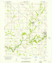
1956 Map of Waldron
USGS Topo · Published 1973About this map
The winding course of Flatrock Creek and its many tributaries, including Conns Creek, Deer Creek, and Lewis Creek, define the landscape of south-central Shelby County. During the mid-1950s, this region maintained a balance of agricultural crossroads and small industrial pockets, evidenced by the Stone Quarry and Gaging Sta near Saint Paul. The infrastructure of the era is anchored by the New York Central railroad, which services the central hub of Waldron and the smaller settlement of Prescott. Local life is well-documented through numerous rural institutions such as St Vincent Sch, Pleasant Hill Ch, and the Township Sch. To the southwest, the terrain transitions into the distinctively named Sleepy Hollow and Pleasure Valley, where Vandalia Road follows the creek toward the community of Geneva.
Find a feature on this map
44 named features on this map. Tap any name to fly to it.
Don’t see what you’re looking for? This feature index may not catch every label — zoom into the map to look around manually.
Map Details
Editions of this 1956 Waldron Map
5 editions found
Other maps of this area

1942 · Columbus
USGS Topo · 1:125,000

1947 · Hope
USGS Topo · 1:24,000

1948 · Hope
USGS Topo · 1:24,000

1948 · Lewis Creek
USGS Topo · 1:24,000

1950 · Edinburg
USGS Topo · 1:62,500

1953 · Shelbyville
USGS Topo · 1:24,000

1953 · Cincinnati
USGS Topo · 1:250,000

1956 · Waldron
USGS Topo · 1:24,000

1956 · Rays Crossing
USGS Topo · 1:24,000

1957 · Cincinnati
USGS Topo · 1:250,000